|
|
Rivers,
flowing trough Utena District:
A
divide of Šventoji and Žeimena – two big river
basins – is crossing southeast corner of Utena
District. It winds from southwest to northeast
trough Kuktiškės, Raudoniškis, Ryliškiai,
Klykiai, Sirvydžiai and Antalgė. Šventoji and
its affluents take three quarters of Utena
District area. Average density of rivers’ net is
about 0,8 km/km2; total rivers’
length is almost 1000 km.
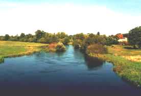 Šventoji
is the biggest river of District. It outflows from
Paštis lake, traverses Utena District land and
flows to southwest part about 30 km till Anykščiai
District bound, where 140 km is left till its
mouth. This range of Šventoji is the most winding.
There are Likančiai, Ilčiukai, Degėsiai, Kaniūkai,
Šeimyniškės, Joniškis, Vėželiai villages and
Užpaliai little town situated on its shores. Two
bridges of ferroconcrete join river’s shores;
one is in Užpaliai, the second is in Kunigiškės
– in a joint of Utena and Anykščiai Districts.
In a range Ilčiukai-Užpaliai Šventoji flows the
most jolly, so why even three watermills were
built here: Ilčiukai mill (destroyed), Degėsiai
mill (destroyed) and Užpaliai mill. In spring
river is the most watery. Going downstream there
are the most significant affluents of Šventoji in
Utena District: Alauša, Karčiupis, Ringys,
Bradesa, Girbys, Vyžuona – from the left and
Narupis, Ūdrokštis, Nasvė – from the right
side. Indraja that flows through Duobiai-Daugailiai-Antadraja-Bikūnai
environs also belongs to the watershed of Šventoji. Šventoji
is the biggest river of District. It outflows from
Paštis lake, traverses Utena District land and
flows to southwest part about 30 km till Anykščiai
District bound, where 140 km is left till its
mouth. This range of Šventoji is the most winding.
There are Likančiai, Ilčiukai, Degėsiai, Kaniūkai,
Šeimyniškės, Joniškis, Vėželiai villages and
Užpaliai little town situated on its shores. Two
bridges of ferroconcrete join river’s shores;
one is in Užpaliai, the second is in Kunigiškės
– in a joint of Utena and Anykščiai Districts.
In a range Ilčiukai-Užpaliai Šventoji flows the
most jolly, so why even three watermills were
built here: Ilčiukai mill (destroyed), Degėsiai
mill (destroyed) and Užpaliai mill. In spring
river is the most watery. Going downstream there
are the most significant affluents of Šventoji in
Utena District: Alauša, Karčiupis, Ringys,
Bradesa, Girbys, Vyžuona – from the left and
Narupis, Ūdrokštis, Nasvė – from the right
side. Indraja that flows through Duobiai-Daugailiai-Antadraja-Bikūnai
environs also belongs to the watershed of Šventoji.
 Vyžuona.
We could call Utena District as “Vyžuona land”,
because here is one third of its area. Total area
of Vyžuona watershed is 414,7 km2. The
river outflows in Molėtai District and its mouth
is in Utena and Anykščiai Districts’ joint.
Its length is almost 30 km. The lower river
reaches are the most beautiful (below Vyžuonos).
Here the river widely winds; its valley is dried
and impacted with high banks. 235 streams, mostly
short – till length of 3 km, sluice water to Vyžuona
and its affluents.
The longest (21,7 km) is Krašuona; its
watershed (68,6 km2) extends to
southeast from Utena and flows through Nemeikščiai,
Biliakiemis, Raudoniškis until Ryliškiai. In
1980 near by Nemeikščiai village the river was
stemmed. A pond of 82,4 ha was made here (length
of a dam is 640 m, height – 12 m). Vyžuona.
We could call Utena District as “Vyžuona land”,
because here is one third of its area. Total area
of Vyžuona watershed is 414,7 km2. The
river outflows in Molėtai District and its mouth
is in Utena and Anykščiai Districts’ joint.
Its length is almost 30 km. The lower river
reaches are the most beautiful (below Vyžuonos).
Here the river widely winds; its valley is dried
and impacted with high banks. 235 streams, mostly
short – till length of 3 km, sluice water to Vyžuona
and its affluents.
The longest (21,7 km) is Krašuona; its
watershed (68,6 km2) extends to
southeast from Utena and flows through Nemeikščiai,
Biliakiemis, Raudoniškis until Ryliškiai. In
1980 near by Nemeikščiai village the river was
stemmed. A pond of 82,4 ha was made here (length
of a dam is 640 m, height – 12 m).
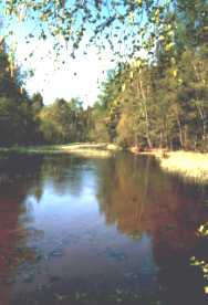 Būka
is maybe the most beautiful little river in Aukštaitija
National Park (its length is 8 km, area of its
watershed is 146 km2). The river
outflows from Utenykštis lake. Till Vainoriškė
village it is very large, but shallow; speed of
its stream is little. Below its trench is getting
narrower and its stream gets more intensive. The
river debouches into Baluošas lake. Būka
is maybe the most beautiful little river in Aukštaitija
National Park (its length is 8 km, area of its
watershed is 146 km2). The river
outflows from Utenykštis lake. Till Vainoriškė
village it is very large, but shallow; speed of
its stream is little. Below its trench is getting
narrower and its stream gets more intensive. The
river debouches into Baluošas lake.
▲
|
